
The drive from northern New Jersey to the Delaware Bayshore takes two hours and brings you through a variety of landscapes.
The heavily industrialized corridors in the north quickly give way to expansive farms and suburbs in central and southern Jersey. While traveling south on Route 55 and Route 49, the scenery changes again from farms to forest and then to wetlands and marshes.
On a recent drive to the region to visit two Dodge environment program grantees, I began to wonder how a place that is ecologically important could be so underrated in New Jersey. Everyone knows about the Jersey Shore on the Atlantic Ocean side and its importance to the state’s economy. But, have you heard of the Bayshore before today?
More so, the Delaware Bay is considered to be one of the most important navigation channels in the United States — it is the second busiest waterway after the Mississippi River.
In the morning Margaret Waldock, Environment Program director, and I met with staff from the Natural Lands Trust to learn more about a property they had recently preserved. The Sunset Lake Preserve is 119-acres of old growth forest located near the Cohansey River in Cumberland County.

Steve Eisenhauer, regional director of Stewardship and Land Protection explained that preserving the land would protect the old growth forest from development and nearby Sunset Lake from pollution. As we walked the trails it felt like were in an oasis in the middle of suburbia. In the hot July sun, I appreciated being provided with much-needed shade canopy from the tall trees.
But, I found it difficult to imagine what the area would look like without the forest. If the land had been developed, it would have been a tremendous loss to locals whom use the trails on a daily basis.
Since I was having such an amazing time on a two-hour site visit, I could only imagine the different kinds of fun other visitors to the property would have. Eisenhauer detailed a few of the trips he led with students from Cumberland and Salem County to visit Natural Lands Trust’s other preserves – the Glades Refuge and Shaws Mill Pond.
For many of the students, these field trips may be one of the few times that they connect with nature and learn about the environment outside of the classroom. So, it is even more critical that Eiesenhauer and his colleagues provide students from underserved communities with access and opportunities to explore the salt marshes and beaches of the Delaware Bayshore.
The Dodge Foundation’s support to Natural Lands Trust highlights their commitment to connecting local youth with the unique ecosystems in their communities especially in Cumberland and Salem counties.
Cumberland and Salem counties are among New Jersey’s poorest. Cumberland’s poverty rate is 20 percent, and Salem’s is 14 percent, according to 2014 Census data. It is even more critical that Eiesenhauer and his colleagues provide students from underserved communities with access and opportunities to explore the salt marshes and beaches of the Delaware Bayshore.

After a quick lunch at a local diner, we headed further south towards Newport to meet with staff from the Partnership for the Estuary to see a few of the shoreline restoration projects they had been managing.
While standing in the marsh around Money Island Marina, I could see that the river was busy with ships and boats entering and leaving the bay. Unlike the Atlantic Coast, this part of the state was developed for commercial activities such as fishing, shipping and oyster harvesting and not tourism.
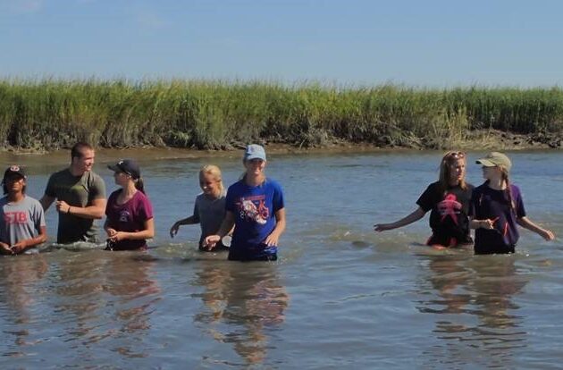
Honestly, I could not contain my enthusiasm as Dr. Danielle Kreeger, the organization’s science director, led us into the muddy waters to get a closer look at living shoreline projects that the Partnership has been constructing and monitoring where the Nantuxent Creek meets the Delaware River.
Kreeger explained how the living shoreline installation is a nature-based method to stabilize the coast from erosion while also preserving or enhancing the native environmental conditions. In the case of Money Island, these marshes had been slowly eroding away and the creeks filling in with sediment causing a loss of habitat and roadway. In the photo above, there are parts of the roadway missing that had fallen into the creek.

This particular project consisted of planting native wetland plants with mussels and empty shells along the tidal water line. Kreeger and the other scientists are using this project to collect data that proves that a living shoreline intervention promotes a high abundance and diversity of organisms, keeps pace with sea level rise, filters pollutants from the water and reduces the potential for downstream erosion issues.
Anecdotally, Kreeger said she has noticed that since the project was installed, fisherman have commented that they can fish for bait in the creek again and roadway flooding has reduced.
The Bayshore is a part of New Jersey that should not be overlooked.
Even a short visit with Natural Lands Trust and Partnership for the Delaware Estuary provide a glimpse the work they are doing to preserve the unique value this region has to offer and why these ecosystems need to be protected and preserved for future residents of the state.